Starting point

Born: 2, Schlassstroos

Destination

Born: 2, Schlassstroos

Distance
7,51 km
Duration
2:05 h
Difficulty
medium
  • Condition
Highest point
313 Hm
Lowest point
146 Hm
Aggregated Ascent
168 Hm
Aggregated Descent
168 Hm
Circular routes Visit Luxembourg

Description

The path leads through the picturesque village of Born,then along many orchards (Bongerten) and through the forest and along the Girsterbach.


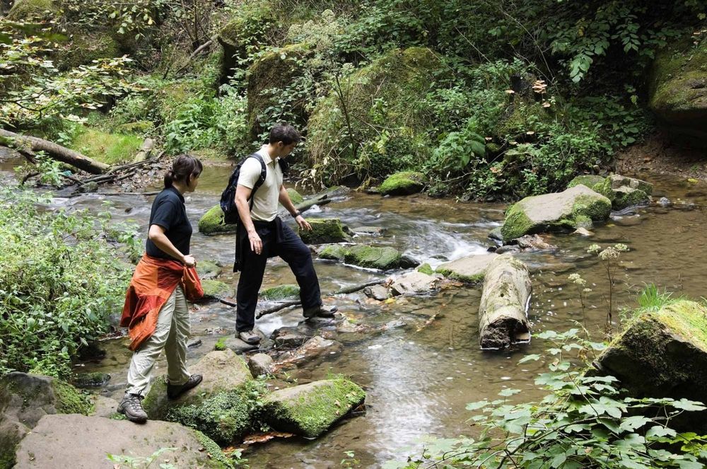
This trail crosses the valley of the Girsterbaach close to the Burermillen after following the national “Sentier de la Basse Sûre” stage trail until Burerbësch. In some parts, you will have to cross the creek stepping on stones, so be sure to wear sturdy shoes.

At the end of the hike, the trail passes by Ramborn Cider Haff, Luxembourg’s first cider producer. The fruit used for the production of the ciders and perries comes from the surrounding orchards, which you have already had the chance to explore during your hike. At the shop of Ramborn Cider Haff, you can sample the various ciders and perries or take part in a tasting session.

Suggestions nearby

Auto-pédestre trail Born

  • Salzwaasserquell
    Salzwaasserquell
    Find out more

Similar hiking tours

©Visit Luxembourg
Circular routes
Auto-pédestre trail Grundhof
Distance: 10,99 km
Duration: 3:15 h
Difficulty: medium
Find out more
©L. Schömer, Visit Luxembourg
Circular routes
Auto-Pédestre hiking trail Bollendorf-Pont
Distance: 8,67 km
Duration: 2:40 h
Difficulty: medium
Find out more
©Visit Luxembourg
Circular routes
Auto-Pédestre hiking route Echternach Centre
Distance: 6,71 km
Duration: 2:00 h
Difficulty: medium
Find out more
©ORT MPSL, Visit Luxembourg
Circular routes
Local hiking trail - R8
Distance: 8,71 km
Duration: 2:30 h
Difficulty: medium
Find out more
©Visit Luxembourg
Mullerthal Trail - Leading Quality Trails - Best of Europe
Mullerthal Trail ExtraTour B
Distance: 12,98 km
Duration: 3:45 h
Difficulty: medium
Find out more
©Visit Luxembourg
Circular routes
Local hiking trail - R9
Distance: 8,91 km
Duration: 2:20 h
Difficulty: medium
Find out more
©Visit Luxembourg
Circular routes
Local hiking trail - B13
Distance: 2,78 km
Duration: 1:00 h
Difficulty: medium
Find out more
©Visit Luxembourg
Circular routes
Local hiking trail - B7
Distance: 11,57 km
Duration: 3:15 h
Difficulty: medium
Find out more
©Visit Luxembourg
Circular routes
Auto-Pédestre hiking trail Junglinster
Distance: 9,17 km
Duration: 2:26 h
Difficulty: medium
Find out more
outdooractive This website uses technology and content from the Outdooractive Platform.